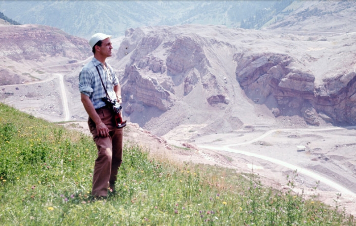
The valley of Vajont (or Vaiont) in the Italian Dolomites is characterized in the upper part by a broad catchment area, carved by ancient glaciers, and in the lower part by a deep and narrow gorge, eroded into limestone formations by the river Vajont. This peculiar shape made the valley a perfect site for a dam and a hydroelectric power station nearby.
History:
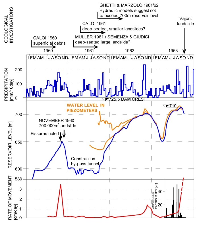
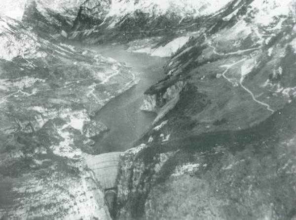
Construction of the Vajont dam started in 1956 and was completed in 1960. At the time it was the highest double-curvature arch dam in the world, rising 261,6 meters above the valley floor and with a capacity of 150 to 168 million cubic-meters. The filling of the reservoir began in February 1960. Eight months later the reservoir was already 170 meters deep. Soon afterward, first fissures were noted on the slopes of Mount Toc, overlooking the Vajont reservoir. On November 4th, with the reservoir 180 meters deep, a first landslide with 700.000 cubic-meters fell into the lake. Alarmed, technicians decided to reduce the filling rate of the reservoir. This strategy was successful until mid 1963, when, between April and May, the depth of the reservoir was rapidly increased from 195 to 230 meters. By July, the depth was 240 meters, another slight increase in the speed of the sliding slope was noted. In early September, when the lake was 245 meters deep, ground movements accelerated to 3,5 centimeters per day. In late September, the water level was lowered in an attempt to slow down slope movements. Even doing so, the ground continued to move at a rate of 20 centimeters per day, enough to open large fissures along the entire flank of Mount Toc. On October 9th, the reservoir’s depth had been lowered almost to 235 meters when the slope began to slide uncontrollable.
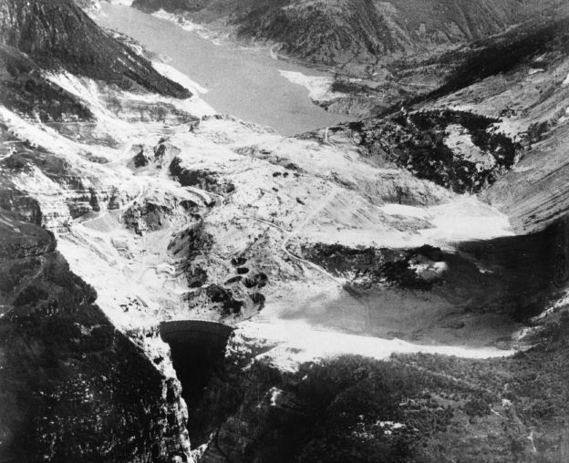
October 9, 1963, at 10:39 p.m. local time, the entire flank of Mount Toc collapsed. Within 30 to 40 seconds estimated 240-270 million cubic-meters of soil and bedrock slipped into the reservoir, containing 115 million cubic-meters of water at the time. The reservoir was partially filled up by and buried by a 400 meters thick packet of rocks. The landslide pushed part of the water out of the lake, generating a wave with a maximal height of 230-240 meters. In the villages surrounding the reservoir – Erto, Casso, San Martino, Pineda, Spesse, Patata, Cristo, and Frasein – the wave claimed 160 victims. A 100-150 meters high wave rushed into the gorge of the Vajont, in direction of the densely populated Piave valley. There the wave destroyed the town of Longarone and the villages of Pirago, Villanova, Rivalta, and Fae. In less than 15 minutes more than 1.900 people were killed.
Geological Surveys:
For more than three years, the movements were monitored and various geologists studied the creeping slope. Shear zones with crushed rocks were discovered during the construction of a tunnel deep inside the mountain. Some geologists warned of a deep-seated landslide, like Austrian engineer Leopold Müller in 1960 and later Italian geologists Eduardo Semenza and Franco Giudici. In July 1964, Semenza, son of the engineer who planned the dam, recognized that the valley of Vayont is partially filled by old mass-movements deposits and gravels of a landslide-dammed lake, suggesting that catastrophic landslides already happened here.
But other geologists proposed superficial sliding planes, able to cause only small landslides. Small landslides, as happened in 1960, were always expected during the filling of the reservoir. In 1961, the construction of a by-pass tunnel was started, just in case the reservoir would become partially obstructed by a landslide. In the same year, calculations, based on a model of the entire reservoir, suggested that a (small) landslide into the lake could generate a 30 meter high wave. Technicians recommended to not exceed a water level of 700 meters a.s.l. – 25 meters beneath the dam crest – surpassed, however, in 1963 by 10 meters.
Geology:
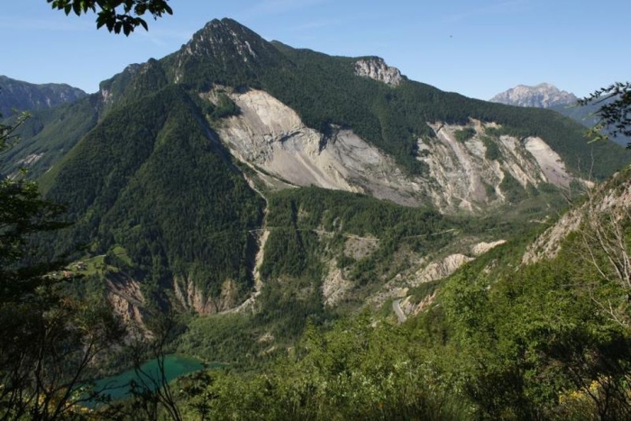
The valley of Vajont is characterized by a succession of Jurassic/Cretaceous to Eocene marl and limestone-formations, forming a large fold, with the valley following the axis of the fold. Sedimentary layers found along the slopes of the mountains, especially on Mount Toc, plunge towards the valley, forming possible sliding planes for a mass movement.
After the disaster, geologists discovered thin layers of green claystone (5-10 centimeters thick) in the limestone of the Vajont site. The clay layers acted as sliding planes for a prehistoric landslide and were reactivated by the rising water level in the reservoir.
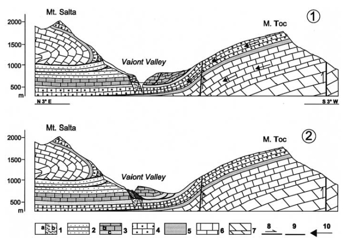
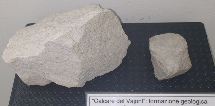
Lower Paleocene); 3 Cretaceous-Jurassic Formations (Socchér Formation sensu lato and coeval): b Socchér Formation sensu stricto; c Ammonitico Rosso and Fonzaso Formation; 4 Calcare del Vaiont (Dogger); 5 Igne Formation (Upper Liassic); 6
Soverzene Formation (Lower and Middle Liassic); 7 Dolomia Principale (Upper Triassic); 8 faults and overthrusts; 9 failure surfaces of landslides; 10 direction of water flow into aquifers (from SEMENZA et al. 2000).
Conclusion:
The continuous rejection of the worst-case scenario by authorities and the electric power company, running the dam, was, in part, based on a lack of understanding of large mass movements at the time. Only a few geologists and engineers imagined that an entire flank of a mountain could collapse.
But likely the most important factor contributing to the catastrophe was of financial nature. The Vajont reservoir was an important economic investment, providing energy to nearby large cities and industries, and many politicians supported its construction. Nobody wanted to abandon the entire project until it was too late.
References:
- SEMENZA E. (1965): Sintesi degli studi geologici sulla frana del Vajont dal 1959 al 1964. Museo tridentino di scienze naturali, Trento Vol. 16(1): 51
- SEMENZA, E. (2005): La storia del Vajont raccontata dal geologo che ha scoperto la frana. K-Flash editore: 280
- SEMENZA, E. & GHIROTTI, M. (2000): History of the 1963 Vaiont slide: the importance of geological factors. Bull Eng Geol Env 59: 87–97