„Like Venus, the theory of plate tectonics is very beautiful and born out of the sea.“
R. Trümpy, 2001
For over 200 years the Alps have been visited by geologists. For most of this time, they wondered how mountain ranges like the Alps formed. Folded sediments suggested forces pushing and squeezing the rocks. In the 18th century Swiss naturalist Johann Jakob Scheuchzer depicts and describes folds in the Swiss Alps, explaining them as layers deposited and then folded by the biblical flood.
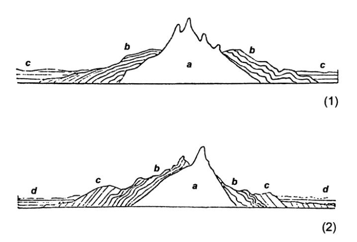
German geologist Leopold von Buch (1774-1853) was convinced that mountains form like a bubble in Earth’s crust. Large magma intrusions displace and fold the superficial sedimentary layers. Von Buch believed that his theory could also explain the complex geology of the Alps, with magmatic and metamorphic rocks forming the inner zones and sedimentary rocks (like found in the Dolomites and the Northern Calcareous Alps) forming the outer borders. Based on von Buch’s research, French geologist Elie de Beaumont proposed that tilted and folded layers of different age were formed by periodic „magmatic“ pulses. At first, the horizontally deposited sediments are uplifted by the intrusion of a magmatic core. In a second phase, the layers become tilted and then new layers form by the erosion of older layers. The undeformed layers are tilted by a new orogenic cycle and so on. However, British geologists later showed that this theory couldn’t work as proposed. If a mountain formed around a magma intrusion, all the sedimentary layers should show similar strike and dip, but the strata in the Alps were tilted chaotically.
A new theory – the Contracting Earth theory – was later formulated by American geologist James
Austrian geologist Eduard Suess suggested in his book Die Entstehung der Alpen (1875; The Origin of the Alps) and multi-volume work Das Antlitz der Erde (1883-1909; The Face of the Earth, English edition 1904-1924) that deep-sea trenches found along the borders of the Pacific Ocean are zones where the seafloor is pushed beneath the continents. However, also Suess imagined that „the horizontal and uniform movements“ of rock layers could be explained by variations in Earth’s circumference. In 1906, Austrian geologist Otto Ampferer imagined with his “Unterströmungstheorie“ large currents in Earth’s mantle, pulling the upper crust, creating mountains like folds in a carpet. However, Ampferer and many other geologists working in the Alps used such theories only to explain very localized tectonic movements, like the thrust belt found in the Northern Calcareous Alps, mapped by Ampferer.
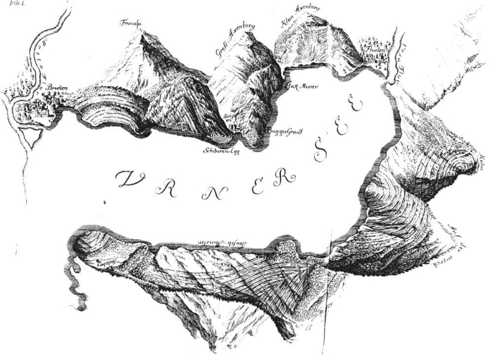
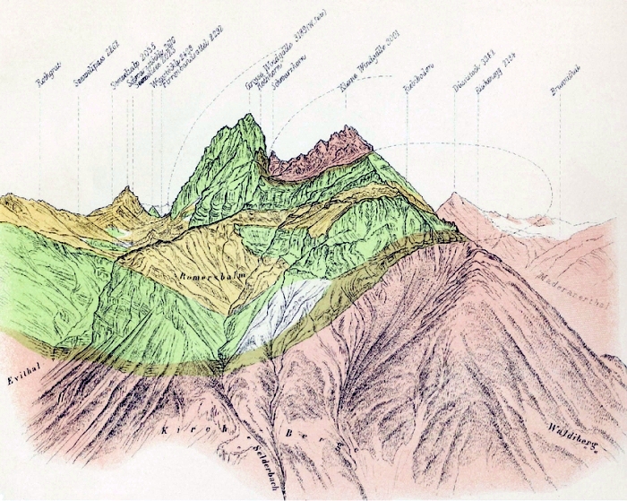
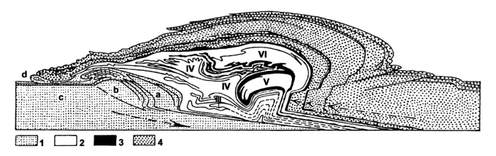
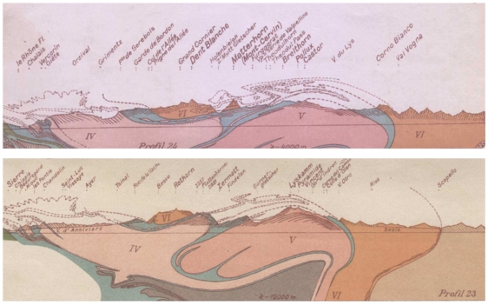
Thrusts had been noted in the Alps since the middle of the century, for example by Bernhard Studer (1853) and Arnold Escher (1841). In the Glarus Alps a spectacular thrust – here older Permian red beds and Mesozoic limestone cover younger Eocene to Oligocene Flysch – was explained by Escher and later by Albert Heim as a large „double fold“, a recumbent fold with inverted layers. In 1884, Marcel Bertrand proposed that a single, north-facing tectonic nappe could explain the inverted stratigraphy. The nappe was thrusted on older layers by the gravitational collapse of the mountains, when single sheets of sedimentary rocks sliding downwards get stacked atop each other.
The Contracting Earth theory could explain the immense forces needed to crack and fold rocks on a global scale. However, it failed to explain the irregular distribution of mountains on Earth. According to the Contracting Earth theory, features like mountain ranges should be distributed randomly on the uniformly shrinking planet. However, even a short glimpse on a map or globe shows that mountain ranges are not randomly distributed, but rather form long chains, like the Alps, the Caucasus and the Himalayas; or are instead found along one side of a continent, like the Rocky Mountains or the Andes, but not on the other side.
In January 1912 the German meteorologist Alfred Wegener presented in his public lecture Die Heraushebung der Großformen der Erdrinde (Kontinente und Ozeane) auf geophysikalischer Grundlage (The formation of large features of Earth’s crust (Continents and Oceans) explained on a geophysical basis) for the first time his idea of the ancient supercontinent Pangaea, from which all modern continents split apart. Three years later he publishes his book Entstehung der Kontinente und Ozeane, translated in the third edition and published in 1922 as The origin of continents and oceans. According to Wegener, ocean basins form as continents split apart, mountains are formed as continental crust collides with the oceanic crust or other fragments of continental crust. Swiss geologist Émile Argand used in 1916 Wegener’s hypothesis to explain the closure of the Tethys Ocean, once located between Europe and Africa, and subsequent folding and overthrust of marine sediments on the continental crust of Europe.
Despite Argand’s nappe theory could explain many mysteries of Alpine geology, like old and young rocks found together or the tectonic structure of the Alps, it would need almost another 50 years until it was widely accepted.
Wegener’s continental drift theory (a catchy phrase adopted mainly by his critics, as Wegener talks more general of displacement theory) was received with mixed feelings. Most geologists regarded it as cherry-picking of data. Only a few geologists became convinced of his idea. Wegner himself reacted to the critics and tried to respond to them in various editions of his book, however with moderate success. The greatest problem facing Wegener was the lack of direct evidence for the movements of continents. No mechanism was known to be powerful enough to move entire continents. Wegener proposed gravitational pull, tidal and centrifugal forces, but British geophysicist and astronomer Harold Jeffreys (1891-1989) demonstrated that such forces are too weak to explain moving continents. Wegener will die in 1930. His continental drift theory is in many aspects erroneous. Not the single continents move, but fragments of Earth’s crust and the driving forces comes from within the planet, not from the outside. But Wegener’s work introduced the idea of moving continents to the scientific community and the public and decades later this legacy will influence a new kind of theory – modern Plate Tectonics.
Between 1959 and 1977, geologists Marie Tharp and Bruce Charles
References:
- DalPIAZ, G.V. (2001): History of tectonic interpretations of the Alps. Journal of Geodynamics 32: 99-114
- FRANKS, S. & TRÜMPY, R. (2005): The Sixth International Geological Congress: Zürich, 1894. Episodes, Vol. 28, no. 3: 187-192
- HEIM, A. (1919-1922): Die Geologie der Schweiz.
- SEARLE, M. (2013): Colliding Continents: A geological exploration of the Himalaya. Oxford University Press: 438
- STÜWE, K. & HOMBERGER, R. (2011): Die Geologie der Alpen
aus der Luft. Weishaupt Verlag: 296 - TRÜMPY, R. (2001): Why Plate Tectonics was not invented in the Alps. Int J Earth Sciences Vol. 90: 477-483
- TRÜMPY, R. & WESTERMANN, A. (2008): Albert Heim (1849-1937): Weitblick und Verblendung in der alpentektonischen Forschung. Vierteljahrsschrift der Naturforschenden Gesellschaft in Zürich 153(3/4): 67–79