Battlefield Dolomites: How Geology Shaped Mountain Warfare

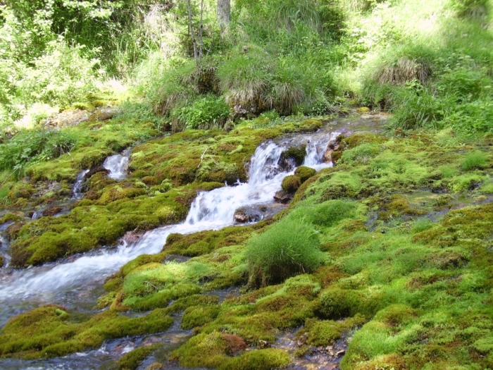
The Great War (1914-1918), fueled by technological innovations and the industrial revolution, was a new type of war. Every corner of the world was touched, from the sea to the highest peaks of the Alps. Entire landscapes were devastated by high-energy explosives.

The Lagazuoi overlooking the Falzarego-Pass in the Dolomites. During WWI the Austrian front-line followed the crest of the mountain, the Italians occupied the ridge in the middle of the cliff.

May 23, 1915, Italy declares war on Austria-Hungary, bringing the war also into the Dolomites. The Austrian military high command fears that the Italian army now can reach the capital city of Vienna in just a few days, so the local troops are ordered to fortify the most important routes and mountain passes in the region. There was no experience with combat in such an extreme environment. Braced by snow-capped mountains, neither side can find a way to dislodge their enemy.

Simplified geological map of the Alps.

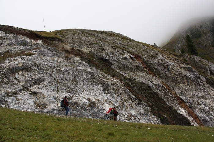
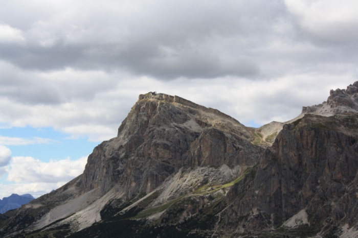
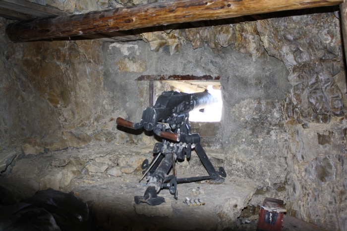
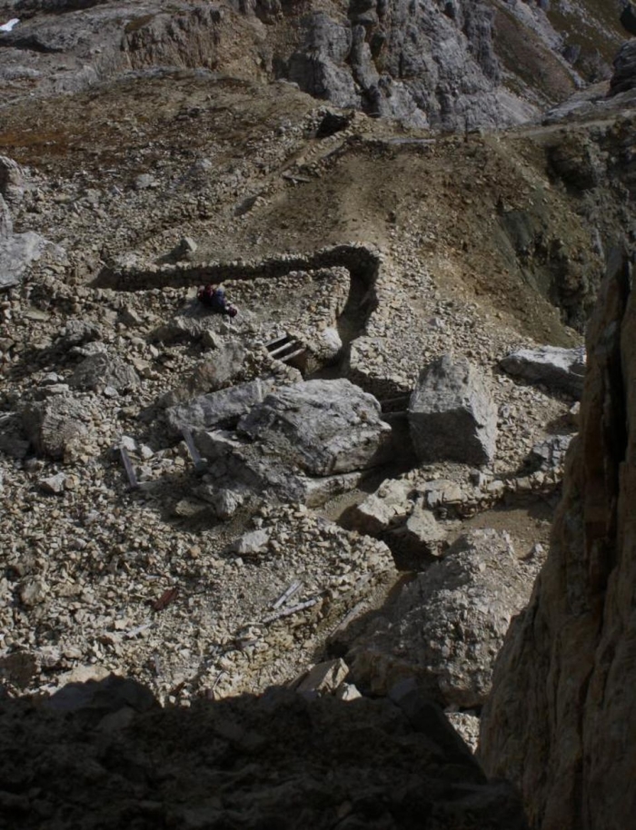
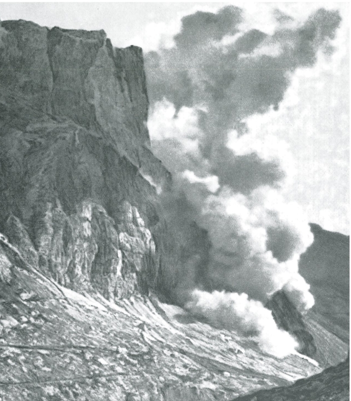
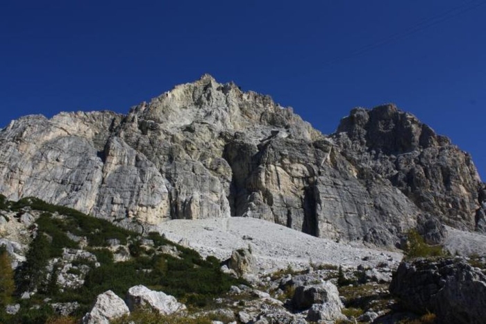
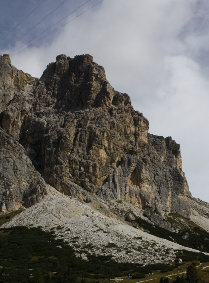
Of strategic importance was the Falzarego-Pass. The nearly vertical cliffs of the Lagazuoi, a 2.835 meter-high mountain, overlook this pass. The Austrian forces fortified the mountain summit, attacked from below by the Italian forces. It was almost impossible to directly attack the enemy, defending himself with machine-gun nests and taking shelter behind rocks. The military tried to solve this problem with tactics first successfully adopted in the plains of France. Tunnel warfare involves the construction of long tunnels beneath the enemy lines, large quantities of explosives are then detonated to form a breach. In the Dolomites, explosions were also used to trigger rockfall and kill the enemy.

Machine-gun nest overlooking the Lagazuoi, hidden in a cavern built into Cassian-Dolomite.

In July 1916, to reach the Italian position located on a rock ledge (formed by a large fault) on the southern side of the Lagazuoi, the Austrian army started to dig a tunnel from the northern side. Adopting a similar strategy, the Italian army tried to dig a tunnel beneath the peak of the Lagazuoi. The Austrians detonated the first mine on January 14, 1917.

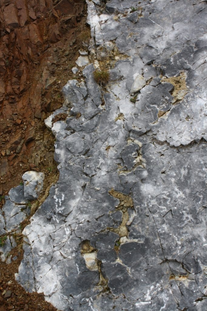
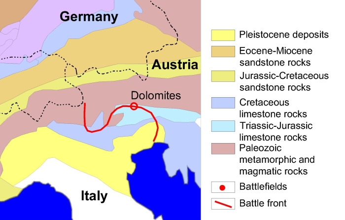
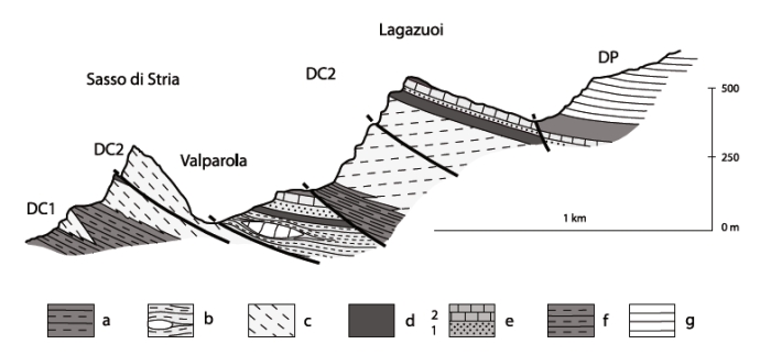
The Lagazuoi is composed of the Cassian-Dolomite, the dolostone core of a former Triassic reef. The relative plain summit of the Lagazuoi is formed by erodible marl deposits of the Heiligkreuz- and Travenanzes-Formation. The Falzarego-Pass and nearby Valparola-Pass are located in the former basin sediments (soft sandstone and marl formations) separating the Lagazuoi reef from nearby carbonate platforms.

Cross-section through the Lagazuoi. a) San Cassiano Fm; b) shallow-water deposits of the San Cassiano Fm; c) Cassian Dolomite; d) Heiligkreuz Fm ; e) Dibona sandstone, (1) lower member of marls, calcarenites and sandstones; (2) upper carbonate beds; f) Travenanzes Fm; g) Dolomia Principale (Trombetta 2011).

The hard dolostone is deformed and broken by tectonic forces. However, the rock was much harder to excavate than expected. Working incessantly the miners were able to advance 9 meters a day. Between 1915 to 1917, when the war in the Dolomites ended, more than 34 such tunnel blasting operations were attempted, 20 by the Italian and 14 by the Austrian military.

WWI trench on the Lagazuoi summit dug into the softer Heiligkreuz- and Travenanzes-Formation.

In 1917, shortly before detonating a mine, the Italian soldier Luigi Panicalli wrote: “I realize that in just some moments the results of all the months of work and suffering will become visible. I’m like petrified. In the last moments my thoughts are by the enemy – poor guys – do they feel death approaching? Do they know, that the enemy is inside the mountain, ready to blast them from the mountain down into their graves?“

Detonation of a mine on the Lagazuoi by the Italian forces May 22,1917, to dislodge the Austrain forces still occupying the summit. 41 soldiers were killed.
Crater and debris formed by a mine on May 22, 1917.
Crater and debris formed by mine detonation on June 20, 1917.

References:

Alexander von Humboldt in the Dolomites

In September 1822, the two German geologists Alexander von Humboldt and Leopold von Buch visited the village of Predazzo in the valley of Fiemme, Italian Dolomites.

Alexander von Humboldt and other famous geologists visited and studied the Dolomites.

This locality was famous among geologists due to a geological mystery found nearby in the volcanic complex of Predazzo and Monzoni.

According to Neptunism, a scientific theory very popular at the time among German geologists, all rocks were formed by sedimentation from a primordial sea. Neptunists believed that coarse-grained granite bodies were the first rocks to crystallize, always followed by younger layers of schist and sedimentary rocks. However, near Predazzo a massive granite body covers the layers of limestone and therefore is the younger geological formation. Von Buch explained this puzzling observation as a result of a large landslide, disturbing the order of the rocks, but Humboldt was not convinced by this explanation.

The outcrop above the village of Predazzo today and a sketch from 1849. The limestone-marble (“Kalkstein”), also referred to as “predazzite“, surrounds a large intrusive body of “granite” (a monzonite-syenite). This was impossible according to the prevailing geological theories of the 19th-century, as the crust of the Earth was imagined to consist of ordered layers of various rock-types.

During a five-year long expedition to South America, Humboldt visited and studied many volcanoes. During a stop at the island of Tenerife in June 1799, he climbed the Pico de Teide, the first active volcano Humboldt examined. Humboldt climbed many more volcanoes in the Andes, studied mineral collections and visited mines. He was particularly impressed by the hard work he saw in the silver mines of Peru. Like he did in Germany, the former mining engineer criticized the adopted mining technologies as inadequate, outdated and dangerous for the miners. In November 1801, Humboldt climbed the active volcanoes of Puracé and Paramos of Pasto. Bad weather prevented the ascent to the Galeras. In January 1802, he climbed the Antisana and Cotopaxi, the highest active volcano on Earth. Humboldt climbed and sketched the active Pichincha in Equador. The day after Humboldt’s return, an earthquake hit the nearby city of Quito and Humboldt was suspected of sorcery, awakening the sleeping volcano. Fortunately he was able to convince the locals that the earthquake was not supernatural, but a natural event.

Humboldt returned to Europe in August 1804. A year later he traveled, together with Leopold von Buch and Joseph Louis Gay-Lussac, to Italy. Visiting Naples, the three geologists repeatedly climbed Mount Vesuvius and witnessed the eruption of August 1805.

As a young geology student, Humboldt considered himself a Neptunist. He believed that the fires visible in the crater of an active volcano were fed by large subterranean coal layers. But after observing the active volcanoes in the Andes and Italy, with no coal deposits found nearby, and studying the particular rock types found near Predazzo, Humboldt quickly “converted” to Plutonism.

Plutonism is named after the Roman god of the underworld. Plutonists believed that volcanism plays a major role in the formtion of rocks. Large chambers of molten magma exist within Earth’s crust. Volcanoes are connected to those magmatic chambers by volcanic conduits and as the magma erupts, it cools quickly and forms the fine-grained lava. If the magma cools slowly, still stuck in the subterranean chambers, it will form an igneous rock with large crystals. Erosion will remove the overlying rocks and expose the crystallized rock as granite. This, so Humboldt, likely happened also near Predazzo.

Basaltic dikes (“serpentinite”) cutting through marbles (“modified limestone”) in contact with a magmatic intrusion of “granite”. Figure from Geo-Mineralogische Skizzen über einige Täler Tirols, 1848.

Some 230 million years ago molten magma was injected under great pressure in the older limestone formation, deposited in an ancient sea. The magmatic intrusion and magmatic dikes cut through the limestone, causing the rock succession that baffled 19th-century geologists. Slowly cooling over the ages, the magma solidified and crystallized to form the monzonite-syenite, at the same time the limestone was transformed by the great heat coming from the magma intrusion into predazzite, a sort of marble.

228-237 million years old magmatic dikes cutting through marbles (former reef limestone), as seen at the locality of Mountain of Dos Capel near Predazzo.
Contact metamorphism between a basaltic dike and former reef limestone.
Samples of predazzite – a contact-metamorphic limestone named after the village of Predazzo.
The volcanic rocks of Predazzo are associated with the volcanic system of Monzoni, a large volcano that erupted some 230 million years ago. It is also the type locality of the granite variety monzonite.

References:

  • AVANZINI, M. & WACHTLER, M. (1999): Dolomiti – La storia di una scoperta. Athesia, Bolzano: 150
  • DELLANTONIO, E. (1996): Geologia delle Valli di Fiemme e Fassa. Museo Civico “Geologia e Etnografia” Predazzo: 72

Geology Of Beer

Chemical traces of beer have been found on fragments on a jar that’s more than 4,000 years old. In ancient Mesopotamia people using ingredients of poor quality to brew beer could be put to death. The Ancient Egyptians considered it to be an essential part of the afterlife. The gods of the Vikings loved it and still today beer is the preferred drink of geologists.

Beer and layers of a limestone formation. Groundwater from areas with carbonate rocks provides many elements needed during the perfect brewing process.

The quality of a beer depends on the quality of the used ingredients. One of the most important ingredients during the brewing process is water and geology strongly influences the chemistry and quality of water. Many breweries use private springs or water wells to satisfy their needs and even reference the supposed (often secret) water quality or purity in their advertisements. Natural water contains four elements especially important for the brewing process: calcium (Ca), magnesium (Mg), sodium (Na) and potassium (K). The concentration of these elements depends strongly on the geology of the catchment area and the source rocks of the springs or wells where the water is extracted.

In areas with water-soluble rocks like limestone, dolostone and gypsum the groundwater has a high concentration of calcium and magnesium. Calcium stabilizes the enzymes used by the yeast to break down starch and sugar into alcohol. This element also precipitates the in water naturally occurring phosphate, correcting the pH-value of the mash, an important factor controlling the microbial activity and alcohol production. Magnesium has similar effects, although too much magnesium can give the beer a bitter taste. Too high concentrations of sodium and potassium can also have an undesirable laxative effect on the heavy drinker. Other elements, like iron or zinc, can give the beer a strange metallic flavor or cause it to become cloudy. Sulfate (SO4), deriving from evaporitic rocks and gypsum, can give the beer a desirable, slightly bitter flavor, by supporting the release of oils from hops and reacting with magnesium to produce magnesium sulfate
(Mg(HSO4)2, a bitter tasting salt. Also, water from springs with a high concentration of chloride and sodium from salt deposits can add a salty or even bitter flavor to a beer. However, in the correct proportions, the sweetness of the chloride ion prevails, resulting in the taste of a classic ale.

A natural occurring spring – the location and discharge of a spring is significantly influenced by geology.

Adding gypsum (Ca[SO4]·2H2O) to water is still known as “Burtonisation” after the city of Burton-upon-Trent, northwest of London, England, where in the 19th century more than 30 breweries used the springs and wells located in limestone and gypsum rocks for their beer.

By contrast, regions with sandstone-formations or metamorphic rocks are characterized by water with a low concentration of dissolved minerals. The lack of the previously mentioned elements in the brewing process results often in a beer with a less distinct flavor. To compensate for this disadvantage, the beer has to ferment for a longer time – preferably in a dark, cool environment, like a lava-cave. The name for Pils or Lager – classic beers from Central Europe – derives from the many caves found there in ancient lava flows and used as “Lager” (storage room) for the beer.

Nowadays, many breweries import their water from elsewhere or even use customized water. Thanks to special membranes undesired elements are filtered out from the natural water and elements are added as the brewmaster desires. This technology guarantees a tasty beer, but sadly for the geologist, the geological secrets behind a pint of beer are lost forever.

Used literature:

CRIBB, S.J. (2005): Geology of Beer. In: Selley, R.C.; Cocks, L.R.M. & Plimer, I.R., Encyclopedia of Geology. Elsevier Academic Press: 78-81