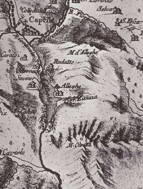
The lake of Alleghe in the Cordévole Valley formed at 7:02 in the morning of January 11, 1771. That day a river flowing through the valley became dammed by a landslide coming from the mountain Piz.
The Alps-traveler and naturalist Belsazar Hacquet (1739-1815) remembers a visit to the lake in 1780:
„The river Cordévole became my guide, by following him I would find the valley of Cadore. However, just after some hundred steps the river was flowing in a large lake, existing here only for the last nine years. I walked around in eastern direction, leaving the villages of Sternade and Saviner behind me, until I arrived at the base of the mountain of Piz. First the lake was narrow, only near Saviner it became more than 100 Venetian fathom [an old length unit used in the mining industry of these times, one fathom ca. 1,8 meter] wide and more than thirty deep.
The last mentioned village once was situated on a hill, and in the valley there were four smaller villages …[]… flooded by the lake, …[]… [the village] Marin, was buried with the village of Riete beneath the collapsing mountain of Piz, the last described village located previously on the top of the mountain.
Standing on the top of the mountain, I immediately noted that the mountain has a volcano on top of it, and it was possible to see how deep [its volcanic dikes] went. After the mountain collapsed, it could be seen that its base was composed of limestone, build up by mighty layers, dipping from west to east with a 45 degrees angle. The [slip] surface of the landslide is so smooth, that a man has difficulties to climb on it to the top of the mountain.„
The strange notion by Hacquet of an active volcano in the Dolomites is based maybe on his discovery of volcanic rocks in the area, however – as we today know – these volcanic deposits are more than 235-million-years-old. At the time of Hacquet’s geologic investigation, volcanic forces were believed to cause strong and sudden movements of Earth, explaining sudden disasters like a landslide.
The landslide of Alleghe killed 48 people and destroyed parts of the village of Riete and some farms. Water levels in the landslide-lake continued to rise over the next weeks, inundating the village of Peron. Only in February 1771, a new outflow formed, stabilizing water levels and creating the modern lake.